


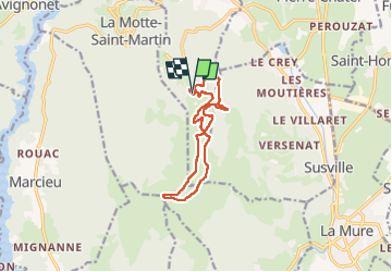
Col du Sénėpy en circuit

Emelle
User

Length
13 km

Max alt
1595 m

Uphill gradient
400 m
Km-Effort
18.3 km

Min alt
1273 m

Downhill gradient
400 m
Boucle
Yes
Creation date :
2024-03-03 08:25:12.832
Updated on :
2024-03-06 11:36:25.283
3h21
Difficulty : Easy

FREE GPS app for hiking
 SityTrail
IGN / Geographical institutes
SityTrail Plus
The world is yours!
About
Trail Walking of 13 km to be discovered at Auvergne-Rhône-Alpes, Isère, La Motte-d'Aveillans. This trail is proposed by Emelle.
Positioning
Country:
France
Region :
Auvergne-Rhône-Alpes
Department/Province :
Isère
Municipality :
La Motte-d'Aveillans
Location:
Unknown
Start:(Dec)
Start:(UTM)
716072 ; 4979316 (31T) N.
Comments